

LINKS
The Polynesian Voyaging Society has a comprehensive discussion of modern wayfinding based on Nainoa Tompson’s studies under master navigator Mau Pialug. Sections of the material cover: designing a course strategy, navigating en route, and finding land. Click here for the website.
Penn Museum has documented research on traditional navigation in the Western Pacific. It provides a useful description of the Micronesian system used by Mau Piailug who appears on the page “The Search for Pattern”. Click here for the website.
Click here to email us. Copyright Arawai Ltd. All rights reserved


Home | Te Aurere | Migration | Wayfinding | About us
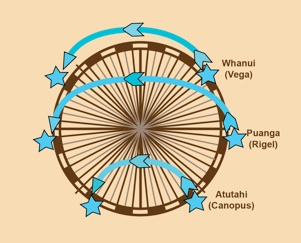
The Star compass contains 32 “houses” with stars appearing to rise in a house in the east and set in the corresponding house in the west. Puanga (declination 8o 12’S), for instance, rises and sets in Rā which is centred on 11.25 degrees south.
When planning for a voyage the navigator will work out the sequence of latitude stars for the journey with particular emphasis on the rising and setting sun. Sometimes in cloudy conditions a peek at the rising sun may be all the navigator gets to help fix the position of the waka.
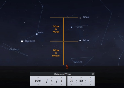
On the sail from the Marquesas to Hawai’i in 1995 Te Aurere was navigated to take the waka to the east of the Hawai’ian island group. The arrival of the waka at the latitude of the Hawai’ian islands was determined using the Southern Cross looking back from the waka. The span across the Southern Cross from Gamma Crux to Alpha Crux is very close to the span from Acrux to the horizon at this latitude.
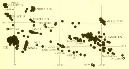
Once Te Aurere reached the correct latitude the waka was turned west to approach the “island screen” of the Hawai’ian Islands - a much safer strategy than trying to sail straight for one island long stretches of open ocean with the risk of missing the target. David Lewis’ map (left) shows island screens in the southern Pacific.
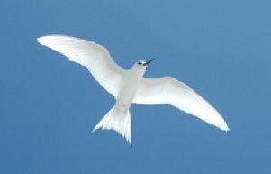
Traditional navigators used a range of signs that they were close to land before they could actually see it. On the deck of Te Aurere a small atoll with just coconut trees growing on it would only be visible within about 7-10 miles. Clouds hanging over high islands, reflections of lagoons in the sky, plants washed out into the ocean after a storm on land, wave refraction patterns, and birds coming out to fish during the day and then returning to their home island are all signs used for expanded landfall.


SOME READING
David Lewis, (1994), We, the Navigators: The Ancient Art of Landfinding in the Pacific. 2nd Edition. Honolulu: University of Hawaii Press.